


출처 : https://www.over-view.com/

이렇게 보면 좀 칼데라 같은가요?

https://watchers.news/2011/06/22/is-thera-volcano-on-santorini-island-waking-up/?replytocom=1258

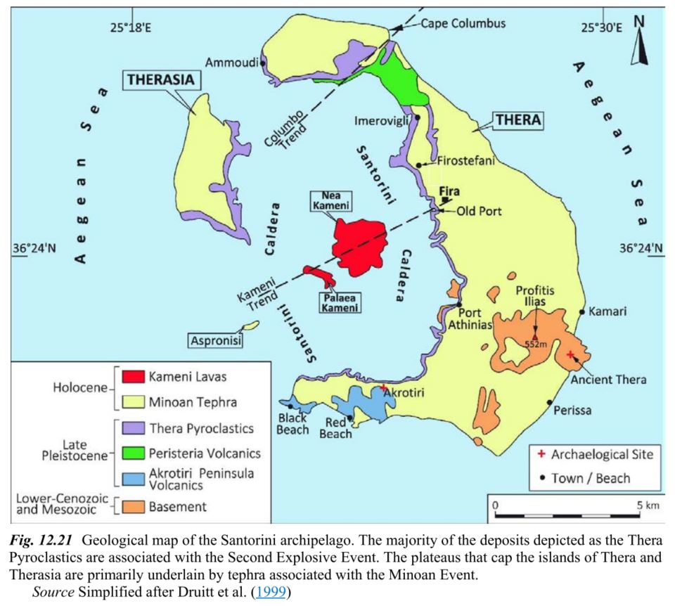
출처 : Volcanic Tourist Destinations (geoheritage, Geoparks And Geotourism) (2014) Springer - 72page

맨위의 사진과 같은 멋진 풍경의 사진을 찍으려면 섬의 어디로 가야할까요?
(정답은 Oia)
경치가 탁 트이면서, 남쪽을 바라보는 곳이 가장 좋은 입지일 듯 합니다.
칼데라의 특성을 파악할 수 있으면
쉽게 고르실 수 있을 듯 합니다.

칼데라의 형성과정

출처 : history.com

남향을 바라보면서 앞이 탁 트인 경치를 감상할 수 있는 입지입니다

출처 : Earth - Portrait of a Planet (5th) by Stephen Marshak (2015) - 307page
칼데라 형성 과정을 담은 동영상입니다.
Santorini Volcano History from Nikos Korakakis on Vimeo.
전세계 16개 지정된 Decade Volcanoes중의 하나인 산토리니입니다.
Decade Volcanoes가 뭐냐면
아래부터는 Wikipedia의 설명입니다.
The Decade Volcanoes are 16 volcanoes identified by the International Association of Volcanology and Chemistry of the Earth's Interior (IAVCEI) as being worthy of particular study in light of their history of large, destructive eruptions and proximity to populated areas. The Decade Volcanoes project encourages studies and public-awareness activities at these volcanoes, with the aim of achieving a better understanding of the volcanoes and the dangers they present, and thus being able to reduce the severity of natural disasters.
They are named Decade Volcanoes because the project was initiated as part of the United Nations–sponsored International Decade for Natural Disaster Reduction, in the 1990s.
A volcano may be designated a Decade Volcano if it exhibits more than one volcanic hazard (people living near the Decade Volcanoes may experience tephra fall, pyroclastic flows, lava flows, lahars, volcanic edifice instability and lava dome collapse); shows recent geological activity; is located in a populated area (eruptions at any of the Decade Volcanoes may threaten tens or hundreds of thousands of people, and therefore mitigating eruption hazards at these volcanoes is crucial); is politically and physically accessible for study; and there is local support for the work.
여기부터는 NASA의 설명입니다.
The islands in this photograph (taken from the International Space Station) are arranged in an oval shape.
They are all that remains of what was once a large, circular volcano.
The largest island in the ring is the tourist mecca of Santorini (also known as Thira),
while the other islands are Thirasia and Aspronisi.
The three pieces are what remains after an enormous eruption destroyed most of a volcanic island.
Water from the Aegean Sea rushed in to fill the void, forming the central, 12 kilometer-long (7.5 mile) lagoon.
The lagoon is surrounded by high, steep cliffs on three sides. Several towns occupy the top of these impressive,
near-vertical cliffs (roughly 300 meters, or 1,000 feet), appearing as white stipple patterns from the traditional whitewash paint
that is almost exclusively used on these islands.
Santorini is one of the most famous tourist islands on Earth.
Ships arrive at the bottom of the cliffs near the town of Fira. Tourists
then climb a switchback road up the cliffs to the town—a classic Greek village
on a cliff face looking out into the great lagoon.
West of Fira, the water has a darker, ruffled texture from wind streaking across the lagoon on the downwind side of the islands.
The wake of a boat also appears between Thirasia and Aspronisi.
The caldera explosion that made this lagoon is one of the largest known to geologists.
An estimated 100 cubic kilometers of material blew out of the volcano,
four times as much as the well-recorded eruption by Krakatoa in 1883.
Santorini has been designated a “Decade Volcano”
because it poses more than one volcanic hazard to people living near it.
The date of the Santorini explosion has been carefully researched
and is now known to have taken place between 1600 and 1627 BCE.
Archaeological excavations at the town of Akrotiri are revealing exciting remains of a Minoan-age town
with streets, three-story houses, and frescoes well preserved under ash layers,
much like those preserved at Pompeii.
Since the volcano is still active, the central peak has grown and then erupted repeatedly.
Nea Kameni is the most recent peak of the underwater volcano to appear above water (popping up in 1707).
There have been three eruptions in the twentieth century alone.
Recent lava flows appear as dark-toned areas, compared with the lighter-toned surfaces of the older outer islands.

한겨레|입력 16.10.17. 10:16 (수정 16.10.17. 14:26)
사진을 클릭해보세요~

출처 : Conde Nast Traveller UK - 2017.12 (THE ISLANDS ISSUE)

'주제별 자료 > 화산지형' 카테고리의 다른 글
| 아메리칸 사모아의 용암동굴이 만들어 낸 비경 (0) | 2017.06.09 |
|---|---|
| 화산의 두 얼굴 (Fertile but dangerous) (0) | 2016.12.25 |
| Earth’s extensive igneous provinces (용암대지 포함) (0) | 2016.10.14 |
| 하와이 본섬의 최대도시 '힐로'의 입지는 무역풍과 지형의 조화 (0) | 2015.11.03 |
| 대만의 주상절리, 주상절리에 발달한 토양 단면 (0) | 2015.06.18 |