
캘리포니아의 오렌지가 이런 냉해를 입을 수도 있습니다.
어떻게 이런 일이?

분지지형에서 나타날 수 있는 기온역전현상이 그 원인입니다.
한국지리 교과서에서도 두가지 방지대책을 제안하고 있습니다.
1. 바람개비
2. 불피우기
1번 사례는 인터넷에서 쉽게 찾아볼 수 있었는데

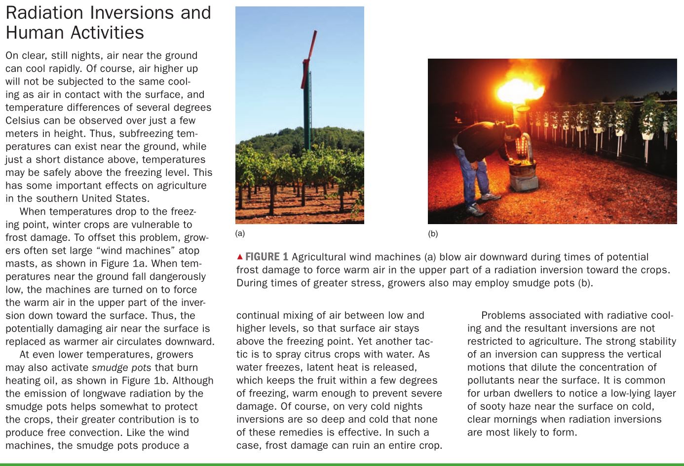
<워싱턴주의 사과농장의 사례>

<바람개비를 돌려 역전 curve를 완화시켜 지표면 온도를 -5에서 -2도 정도까지 만듭니다>
2번 불피우기 사진을 볼 수 없었습니다.
그러다 FAO홈페이지에서 발견했습니다.
이 밖에도 기온역전에 의한 과수농가 피해를 방지할 수 있는 여러가지 사례들을 볼 수 있었는데요
오늘은 불피우기 사진을 소개하도록 하겠습니다.


<이 기구의 이름은 Smudge pot라고 합니다.>

An orchard in an imaginary box, where the energy fluxes represented are net radiation (Rn), vertical and horizontal sensible heat flux (H), conductive heat flux from the ground (G), latent heat (LE) and energy added by heating (Q)

Hot air rises and cools until about the same as the ambient temperature, then it spreads out and cools until it becomes denser and descends
; this creates a circulation pattern

Diagram of a frost night temperature profile and the influence of heater output on heat distribution and loss from an orchard
기온역전 커브 곡선의 꼭지점에 해당하는 높이 (기온역전 경계면) = Ceiling(천장)
확산을 방해하니까 천장이라 불러도 되겠네요.
더 많은 정보를 찾아보시려면 FAO홈페이지를 방문해보세요~
Temperature Inversions VS Surface Inversions
Temperature Inversions

이런 형태의 역전층(침강 역전층)은 아열대 고압대에서 주로 나타난다.
왜냐면 아열대 고압대는 꾸준한 하강기류를 발생시킬 수 있는 조건이 되기 때문이다.
아래로 하강시키면 단열압축으로 온도가 올라가고 지표면 공기보다 따뜻해진다.
그림 처럼 지표에서 어느 정도 올라간 높이에서 역전층이 발생하게 된다.
Under certain circumstances, the normal observed decrease of temperature with increased altitude might be reversed; temperature may actually increase for several hundred meters. This is called a temperature inversion.
Some inversions take place 1000 or 2000 meters above the surface of Earth where a layer of warmer air interrupts the normal decrease in temperature with altitude (Fig. 4.20).
Such inversions tend to stabilize the air, causing less turbulence and discouraging both precipitation and the development of storms. Upper air inversions may occur when air settles slowly from the upper atmosphere. Such air is compressed as it sinks and rises in temperature, becoming more stable and less buoyant. Inversions caused by descending air are common at about 30–35° north and south latitudes.
An upper air inversion common to the coastal area of California results when cool marine air blowing in from the Pacific Ocean moves under stable, warmer, and lighter air aloft created by subsidence and compression. Such an inversion layer tends to maintain itself; that is, the cold underlying air is heavier and cannot rise through the warmer air above. Not only does the cold air resist rising or moving, but pollutants, such as smoke, dust particles, and automobile exhaust, created at Earth’s surface, also fail to disperse.
They therefore accumulate in the lower atmosphere. This situation is particularly acute in the Los Angeles area, which is a basin surrounded by higher mountainous areas ( Fig. 4.21). Cooler air blows into the basin from the ocean and then cannot escape either horizontally, because of the landform barriers, or vertically, because of the inversion.
Some of the most noticeable temperature inversions are those that occur near the surface when Earth cools the lowest layer of air through conduction and radiation (Fig. 4.22). In this situation, the coldest air is nearest the surface and the temperature rises with altitude. Inversions near the surface most often occur on clear nights in the middle latitudes. They may be enhanced by snow cover or the recent advection of cool, dry air into the area. Such conditions produce extremely rapid cooling of Earth’s surface at night as it loses the day’s insolation through radiation. Then the layers of the atmosphere that are closest to Earth are cooled by radiation and conduction more than those at higher altitudes. Calm air conditions near the surface help produce and partially result from these temperature inversions.
Surface Inversions: Fog and Frost

이것(접지 역전층)이 지리 시간에 자주 언급되는 기온역전 패턴
접지 역전층은 또 두가지 유형이 가장 흔한데
1. 복사 역전층으로, 이는 바람이 약하고 일교차가 큰 맑은 날 새벽에 생기는 역전층으로, 주로 가을 이나 초겨울에 생긴다. 아침에 해가 뜨고 지면이 가열되면 복사 역전층은 약화되어 정오 이전에 사라지게 된다.
2. 두번째는 이류 역전층은 일반적으로 높새 바람과 관련 지을 수 있는데, 산을 넘어 하강하는 공기가 단열 압축되어 반대편에서 가열되면서 두 공기 경계에서 생기는 역전층을 말한다.
Fog and frost will be discussed again in Chapter 6, but they often occur as the result of a surface inversion. Especially where Earth’s surface is hilly, cold, dense surface air will tend to flow downslope and accumulate in the lower valleys. The colder air on the valley floors and other low-lying areas sometimes produces fog or, in more extreme cases, a killing frost. Farmers use a variety of methods to prevent such frosts from destroying their crops.
For example, fruit trees in California are often planted on the warmer hillsides instead of in the valleys. Farmers may also put blankets of straw, cloth, or some other insulator over their plants. This prevents the escape of Earth’s heat radiation to outer space and thereby keeps the plants warmer. Large fans and helicopters are sometimes used in an effort to mix surface layers and disturb the inversion (Fig. 4.23a). Huge orchard heaters that warm the air can also be used to disturb the temperature layers.
Smudge pots, an older method of preventing frost, pour smoke into the air, which provides a blanket of insulation much like blankets of cloth or straw (Fig. 4.23b). However, smudge pots have declined in favor because of their air-pollution potential.
<From : Physical Geography (9th) - Robert E. Gabler 100page>
'주제별 자료 > 기후-기온' 카테고리의 다른 글
| 중위도 대륙 서안에서 해양성 기후가 더 잘 나타는 원인중 하나는 아열대 고압대? (0) | 2016.09.17 |
|---|---|
| 그라데이션방식으로 채색한 전세계 1월 7월 평균기온 (0) | 2016.09.17 |
| 기온역전이 중국의 6일짜리 휴가를 만들다 (0) | 2014.11.19 |
| 세상에서 가장 뜨거운 곳(LST기준) (0) | 2012.05.02 |
| 열섬현상 (Urban Heat Island Profile) (0) | 2011.04.27 |