아는 만큼 보인다더니, 지도를 다룬 다큐멘터리 '프톨레마이오스'편을 보고 나니, 아래 지도가 더욱 대단하게 보이더군요.

참고로,
교과서, 참고서 모두 프톨레마이오스 지도라고 하면 위의 그림을 많이 사용하고 있습니다.
고대 그리스 시절의 지도가 이렇게 보존이 잘 된 상태로 남아 있었나?
하는 궁금증이 생겨서 찾아보니
위 지도는 르네상스 시대에 새로 만든 리바이벌 버전인 것 같습니다.
위의 지도의 정확한 명칭은
The Ptolemaic system - 1482 world map from Nicholaus Germanus's Cosmographia
출처 : The Phantom Atlas - The Greatest Myths, Lies And Blunders On Maps (2016) - 158page

Ptolemy's World map
From : Great Maps (Dk Smithsonian) by Jerry Brotton (2014) - 24page


그런데 이 책에서 재미 있는 설명중에 이런 내용이 나옵니다.
PTOLEMY’S WORLD MAP Ptolemy plotted the ecumene (known world),
which for him stretched from the Canary Islands in the West to Korea in the East,
with a huge Mediterranean Sea and Indian Ocean in the middle.
맨오른쪽 반도를 두고 이런 말을 하고 있습니다.
THE LIMITS OF PTOLEMY’S WORLD
In the Far East, at the farthest most point on Ptolemy’s map,
is the enigmatic port of “Cattigara,” situated 177 degrees east of the Canary Islands.
Variously believed to be an important port in China, Korea, or even the west coast of the Americas,
it is shown as part of a landmass running all the way to sub-Saharan Africa.
To the west is the promontory known as “the Golden Chersonesus,” believed to be the Malay Peninsula.
Both places fascinated later explorers, including Columbus and da Gama.
출처 : From : Great Maps (Dk Smithsonian) by Jerry Brotton (2014) - 26page
Claudius Ptolemy was the first classical scholar to apply geometry and mathematics to the study of the Earth.
He produced a textbook called Geography (c.150 CE ) that laid down the scientific method for projecting the globe
onto a flat piece of paper (or in Ptolemy’s case, papyrus).
This textbook defined the study of geography, explained how to draw regional and world maps
—using basic geometrical and mathematical principles to create two main projections—
and listed 8,000 places within the classical world.
Ptolemy’s projection remained the template for geographers and mapmakers throughout the next millennia.
Mapping Ptolemy’s world
Ptolemy introduced a basic graticule (a grid of coordinates), using latitude and longitude
derived from centuries of Greek, Persian, Roman, and Arabic data,
and then plotted the inhabited world, which he called the ecumene .
Ptolemy’s world picture stretched from the Canary Islands in the West to modern Korea in the East.
His northernmost point was Thule
—variously identified as somewhere in Scandinavia or the Orkney Islands (off Scotland)—
with the south ending in Saharan Africa, which is connected to Southeast Asia.
There are no Americas or Pacific Ocean in Ptolemy’s geography,
which also overestimates the size of the Mediterranean, but underestimates the Earth’s circumference.
The Geography ’s earliest surviving editions date from late 13th century Byzantium,
leading scholars to question whether Ptolemy actually ever produced a map himself.

<From : Introduction to Geogrpahy 23page>
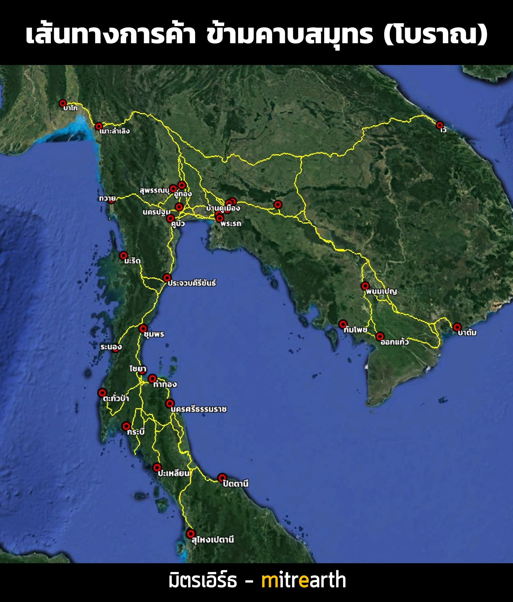
특히 다큐중에서 재미있었던 점은 말레이반도에 관한 내용였습니다.
위 지도의 맨 오른쪽은 육지로 막혀있어서, 로마인들은 인도양이 폐쇄된 것으로 파악하고 있었던 듯 합니다.
다른 말로는, 말라카해협의 싱가포르를 몰랐다는 것이였겠지요.
그렇다면 바닷길로 중국에 가려면 어떻게 해야했을까요?
정답은 태국의 허리춤에 해당하는 지역을 육로로 걸어서 통과해야 했다는 것이지요.

푸켓섬 북쪽의 '태국과 미얀마 국경 사이'를 좀 더 확대해보겠습니다.

태국의 저 지역에서 2000년전의 로마의 구슬들이 발견되고 있고
베트남 남부 해안지역에서 마르쿠스 아우렐리우스의 동전이 발견되기도 한답니다.
다큐멘터리 만드신 분들덕에 좋은 시간 보냈습니다.^^
KMZ 파일

출처 : The Worlds of the Indian Ocean - A Global History (Volume 1) 4000 BCE-6CE (2020) Cambridge Univ -265page

출처 : Terra Incognita - 100 Maps to Survive the Next 100 Years by Ian Goldin (2020)
화장실 갈 때 다르고, 나올 때 다르더니만은..
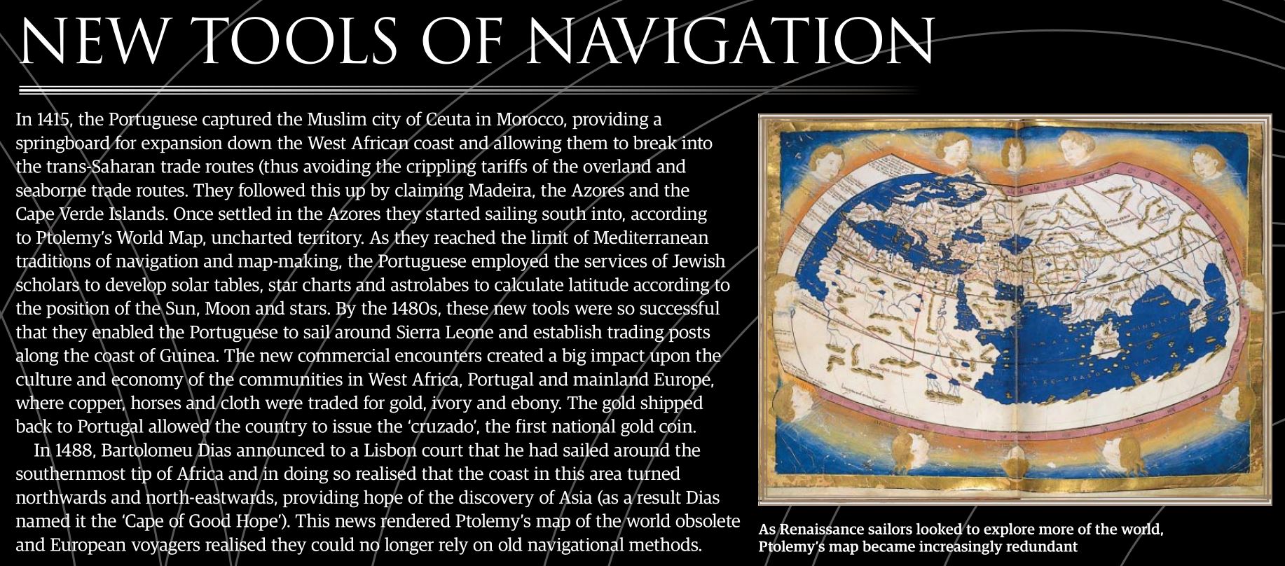
In 1415, the Portuguese captured the Muslim city of Ceuta in Morocco, providing a springboard for expansion down the West African coast and allowing them to break into the trans-Saharan trade routes (thus avoiding the crippling tariffs of the overland and seaborne trade routes. They followed this up by claiming Madeira, the Azores and the Cape Verde Islands. Once settled in the Azores they started sailing south into, according to Ptolemy’s World Map, uncharted territory. As they reached the limit of Mediterranean traditions of navigation and map-making, the Portuguese employed the services of Jewish scholars to develop solar tables, star charts and astrolabes to calculate latitude according to the position of the Sun, Moon and stars. By the 1480s, these new tools were so successful that they enabled the Portuguese to sail around Sierra Leone and establish trading posts along the coast of Guinea. The new commercial encounters created a big impact upon the culture and economy of the communities in West Africa, Portugal and mainland Europe, where copper, horses and cloth were traded for gold, ivory and ebony. The gold shipped back to Portugal allowed the country to issue the ‘cruzado’, the first national gold coin.
In 1488, Bartolomeu Dias announced to a Lisbon court that he had sailed around the southernmost tip of Africa and in doing so realised that the coast in this area turned northwards and north-eastwards, providing hope of the discovery of Asia (as a result Dias named it the ‘Cape of Good Hope’). This news rendered Ptolemy’s map of the world obsolete and European voyagers realised they could no longer rely on old navigational methods.
'주제별 자료 > 지도' 카테고리의 다른 글
| Visualization을 지리수업과 어떻게 연관시킬 것인가? 에 대한 고민 (0) | 2015.03.01 |
|---|---|
| 40 more maps that explain the world (The Washington Post) (1) | 2014.04.24 |
| 발트제뮐러(Waldseemüller)의 지도(1507) (0) | 2012.03.04 |
| Google Earth를 활용한 다큐멘터리 (0) | 2011.12.03 |
| 미국의 지형도를 Google Earth로 (0) | 2011.12.01 |