Google Earth로 확인하시려면 위의 화일을 클릭하세요
Mid-Latitude Cyclone over the United States
벌써 Geowiki라는 블로그를 운영한지가 10달이 다되어 갑니다.
이걸 운영하면서, 지리적 내용이 인터넷에 참으로 많구나 라는 걸 깨닫기도 하고
그렇게 순서없이, 최근 벌어진 사건들을 중심으로 쭈욱 정리하다보니
어떤 연관성이나, 어떤 주제에 따른 정리도 머리속에 저절로 되어가는걸 느낍니다.
아래 사진은 2011년 9월 26일찍은 위성사진인데요
미국에 나타난 Cyclone입니다.
미국에도 월별 계절별로 나타나는 자연재해들이 여럿 된다는 것도 알게 되었습니다.
올 겨울만 하더라도 오대호 인근의 블리자드로 시작해서
봄이 되면 미시시피강 강류지역들의 홍수
멕시코만 지역이 따뜻해지면서 남부평야지대에 발생하는 토네이도
여름이 되면 동부해안과 멕시코만을 강타하는 허리케인
그리고 오늘 소개해드리는 "Mid-Latitude Cyclone" 입니다
* 참고로, 수능때문에 정신이 없어서 요 며칠은 포스팅을 못 했습니다.^^ 업무가 교무기획이라 보니...
* 그리고 호주의 열대성 저기압이 윌리윌리라는데, 이거 자료좀 구할 수 있을라나요?
아무리 찾아봐도 호주에 나타나는 윌리윌리는 운동장에 가끔 나타나는 허리케인 막내동생처럼 휘리릭 거리는 바람이라고 밖에 나오지 않아서요.
우리나라에서만 윌리윌리라 부르는 것 같다라는 느낌이 들어서...
At 3:05 p.m. Eastern Daylight Time on September 26, 2011,
the Moderate Resolution Imaging Spectroradiometer (MODIS) on NASA’s Aqua satellite
observed a mid-latitude cyclone over the midwestern United States.
The center of the storm appeared immediately west of Lake Michigan.
The Capital Weather Gang at The Washington Post reported that
the storm was at its most mature stage on September 26.
Sporting a comma shape spanning hundreds of kilometers,
the storm was comprised of a combination of warm, moist air (clouds) and cold, dry air (cloud-free areas).
Mid-latitude cyclones drive most of the stormy weather in the continental United States.
Development of these cyclones often involves a warm front from the south meeting a cold front from the north.
In the Northern Hemisphere, cyclones move in a counterclockwise direction.
(In the Southern Hemisphere, cyclones are clockwise.)
The bands of cold and warm air wrap around a center of low pressure, and air rising near the center
spurs the development clouds and precipitation.
Justin Berk, a meteorologist based in Baltimore, explains that in this region,
“cold air eventually wins out and wraps completely around a storm.
This is called a ‘cold core’ storm and has cut itself off from the main flow of the jet stream.”
This, says Berk, is why the September 26 storm appears stalled near Chicago.
An animation of the storm from the Geostationary Operational Environmental Satellites (GOES)
shows the storm’s progress from September 25 to September 27.
<From : NASA>
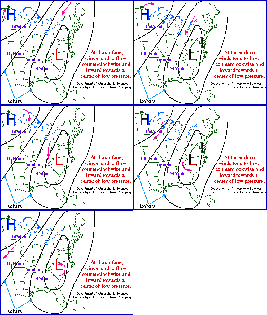
A cyclone is an area of low pressure around which the winds flow counterclockwise in the Northern Hemisphere
and clockwise in the Southern Hemisphere.

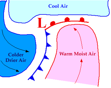
A developing cyclone is typically accompanied by a warm front pushing northward and a cold front pulling southward,
(위의 그림 설명)
marking the leading edges of air masses being wrapped around a center of low pressure, or the center of the cyclone.
The counterclockwise winds associated with northern hemisphere midlatitude cyclones
play a significant role in the movement air masses,
transporting warm moist air northward ahead of a low while dragging colder, drier air southward behind it.

** Press "Reload" to restart the animation **
Rising air in the vicinity of a low pressure center favors the development of clouds and precipitation,
which is why cloudy weather (and likely precipitation) are commonly associated with an area of low pressure.
Cyclones are easily identifiable on certain types of weather maps by remembering some key signatures.
For example, a cyclone can be found on a map of surface observations
by recognizing a counterclockwise rotation of the wind barbs for a group of stations,
while on satellite images, cyclones are identifiable by the trademark comma shaped configuration of cloud bands.
<From : University of Illinois>
'지역별 자료 > 북아메리카' 카테고리의 다른 글
| California’s Central Valley 에 발생한 안개 (0) | 2011.12.06 |
|---|---|
| 미시시피의 홍수가 멕시코만을 죽음의 바다로 만들다 (0) | 2011.11.17 |
| Grand New View of the Canyon (0) | 2011.10.19 |
| 시대별 미국 도시의 확장 (0) | 2011.09.28 |
| Four Corners (0) | 2011.09.27 |
 eastcoast_amo_2011269.kmz